Izhodišče: Puštal (340 m)
| Širina/Dolžina: | 46,1636°N 14,3099°E |
| |
Čas hoje: 2 h 15 min
Zahtevnost: lahka označena pot
Višinska razlika: 518 m
Višinska razlika po poti: 600 m
Zemljevid: Škofjeloško in Cerkljansko hribovje 1:50.000
Priporočena oprema (poletje):
Priporočena oprema (zima):
Ogledov: 16.881
 | 4 osebam je objava všeč |
Dostop do izhodišča:
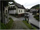
Najprej se zapeljemo v Škofjo Loko, nato pa z vožnjo nadaljujemo v smeri Gorenje vasi. Naprej se peljemo skozi stari del mesta, a le do križišča, kjer se v desno odcepi cesta proti Loškemu gradu. Na omenjenem križišču nadaljujemo levo (smer Puštal), cesta pa nas nato preko reke Poljanščice pripelje v Puštal. Tu se v desno odcepi cesta, ki pelje v dolino Hrastnice, mi pa nadaljujemo levo proti vasi Sora. Tu bomo na desni strani opazili ozko ter strmo kolovozno cesto, ob kateri so planinske smerne table za Osolnik, Tošč in Črni Vrh. Ob izhodišču ni primernih parkirnih mest, zato je bolje parkirati na enem od urejenih parkirišč v Škofji Loki. To nam pot podaljša za približno 10 do 15 minut.
Opis poti:
Od mesta, kjer smo parkirali se najprej sprehodimo do izhodišča, nato pa se usmerimo na širok in strm kolovoz v smeri Osolnika, Tošča in Črnega Vrha. Pot naprej se vzpne ob številnih postajah križevega pota, ki vodijo proti cerkvi sv. Križa na Hribcu, mi pa že kmalu opazimo planinske oznake za Osolnik, ki nas usmerijo levo, sprva nekoliko navzdol. Po nekaj korakih spusta pridemo v manjšo dolinico, pot pa nadaljujemo po strmem travnatem pobočju, kjer se vzpenjamo ob robu pašne ograje. Pot s katere se nam sprva odpirajo lepi razgledi na Škofjo Loko in Kamniško Savinjske Alpe v ozadju, pa gre hitro v gozd, kjer se nato postopoma položi.
Pot naprej nas kar nekaj časa vodi skozi strnjen gozd, mi pa hodimo po poti, ki se nekajkrat strmeje spusti. Čez čas stopimo iz gozda na razgledno travnato senožet, kjer se pot prehodno rahlo izgubi. Le nekoliko višje stopimo na kolovoz in mu sledimo v desno, le ta pa nas hitro pripelje do manjšega znamenja in spomenika NOB, kjer nadaljujemo rahlo levo. Za spomenikom pot zavije rahlo v desno in nas nekoliko višje pripelje v pas gozda.
Ko ponovno stopimo iz gozda, bomo na levi strani opazili samotno domačijo, na desni pa ograjen pašnik. Nadaljujemo naravnost po poti, ki gre v gozd, le ta pa nas kmalu pripelje do makadamske ceste, kateri sledimo v desno. Sledi nekajminutna hoja po cesti, nato pa prispemo do križišča, kjer nadaljujemo naravnost na kolovoz. Nadaljujemo po markiranem kolovozu, ki ima nato v kratkem času kar nekaj razpotij, mi pa se ves čas držimo markacij. Kolovoz se višje spremeni v pešpot, le ta pa se prične strmo vzpenjati ob pašni ograji. Nekoliko naprej se nam z leve priključi pot iz vasi Sora, mi pa nadaljujemo desno ter v nekaj 10 korakih nadaljnje hoje prispemo na vrh Osolnika, na katerem stoji cerkev sv. Mohorja in Fortunata.

Slike:
 1
1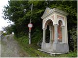 2
2 3
3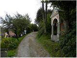 4
4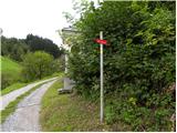 5
5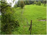 6
6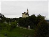 7
7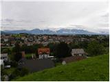 8
8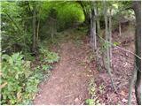 9
9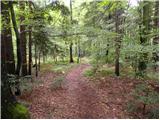 10
10 11
11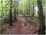 12
12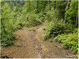 13
13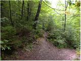 14
14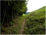 15
15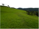 16
16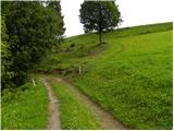 17
17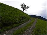 18
18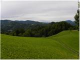 19
19 20
20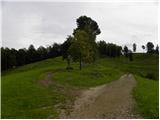 21
21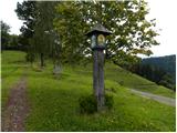 22
22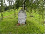 23
23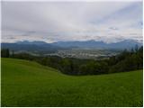 24
24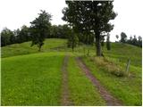 25
25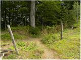 26
26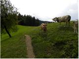 27
27 28
28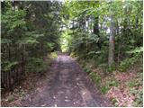 29
29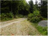 30
30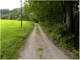 31
31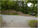 32
32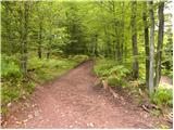 33
33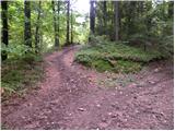 34
34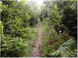 35
35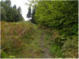 36
36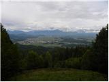 37
37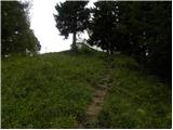 38
38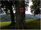 39
39 40
40
Diskusija o izletu Puštal - Osolnik
|
| katty3. 09. 2011 |
Danes spet po dobrem letu na Osolniku  , vendar po nobeni tu opisani poti-stezici. Vseeno zares lepo, edino kar me moti je "zrita" cesta   , še preden prideš do prvega vikenda. Zgleda, da so stezico razširili za kakšne gorske kolesarje ali lastnike vikendov  . Pot je res čudovita, ob zares lepem in jasnem vremenu se nam oči spočijejo  na Kamniško-Savinjskih Alpah (Kočna, Grintovec, Krvavec in Velika planina)  in na Škofjeloškem hribovju (Lubnik in Ratitovec), te sreče pa nisem imela, da bi lahko rekla, da se vidijo Julijske Alpe . Slike in pot pošljem in opišem jutri popoldan. Lep pozdrav, Katy
|
|
|
|
| tol4. 09. 2011 |
Pa kaj vam je? Zrijej onek ocesto pa že mečete gorske kolesarje zravn.
No naj vam povem ,da pravim gorskim kolesarjem vožnja po širokem kolovozu pač ni užitek.
Sploh pa misel, da bi se pri nas v naravi kaj uredilo za kolesarje je tko kot želja, da bom zadel na lotu. Pa še to mam več šans, da zadanem 7.!
Pač poti se ponavad iširi zaradi spravila lesa.
|
|
|
|
| katty4. 09. 2011 |
tol lej, pot definitivno ni tako široka, da bi po njej lahko vozil kak traktor, no, mogoče kak manjši traktorček mogoče. Sicer so bile sledi samo od koles in pohodnikov, nobenih pa od koga druzga. Res, ni pa tako prijetno hodit po razriti poti, kot po obični stezici . Aja, pa ne se zdej jezit no, sej ni nč tazga  .
|
|
|
|
| Darxta4. 02. 2013 |
Danes sem šel dol po opisani poti, a lahko potrdim, da so fotke (in opis poti) še vedno aktualne in precej dobro opišejo pot. Markacije so v redu. Edina novost je asfaltirana cesta do cerkve v Puštalu Sem že hotel reči, da je 2h 15min mogoče malce preveč, a če se spraviš čez prva dva hribčka na začetku poti (Sten in Mrtancova planina) ter imaš lahek tempo, potem lahko rečem, da bo vzelo maksimalno toliko časa Gor sem šel malce naokoli, po cesti skozi Puštal proti Hrastnici in po cca 1,5km levo za hišami ter v gozd, vendar ni nobenih markacij. Je pa ta pot lažja, saj se izogne prvim hribčkom, s tem pa naredimo cca 100 višinskih vetrov manj. Pa tudi kolesarja sem srečal
|
|
|
|
| Darxta4. 02. 2013 |
Aja, naj se malce popravim. Lažja pot samo na začetku nima nobenih markacij, ko enkrat prideš v gozd za hišami, pa se po kakih 100m začne markirana pot
|
|
|
|
| colinbrooks18. 07. 2014 |
This is quite a long walk, nearly all in the forest, but with spectacular views at the beginning, middle, and end. The forest is a maze of paths, and because of recent storms and deteriorating markation it is easy to lose your way. Having a GPS navigation device would be advisable especially in bad weather [although for some strange reason the path at the start is not shown on some versions of Google maps>. A good place to park is at a free public car park on the left after you cross the bridge over the Sora on the road from Skofja Loka to Pustal [there is also a smaller parking area just a little further along the road at the bus stop on the left>. If you choose to do the ascent from Hrastnica [see below> you could drive to where the path starts in Hrastnica, saving about 1.5km of walking and ~100m of climbing. This path is not signposted but it is the cart-track that begins near house 163. The direct ascent from Pustal begins at a signpost about 100m further along the road from the above mentioned parking areas, which directs you up a rough road [a Kalvarija> towards the church at Pustal [which is worth visiting as a detour and for the views of Skofja Loka>. The signpost says 2h to Osolnik but this assumes you walk briskly and continuously and do not have any problems finding the way! Unfortunately, the markation and path-finding problems begin almost immediately, the start of the path to Osolnik being easily missed. It begins at the 7th station of the cross, and is indicated by a now rusty sign post that is in the wrong place, several metres further up the Kalvarija. The path descends a few metres to a dry stream, then ascends steeply up the hill, running SE along a fence that borders a pasture. At various positions along this path there are excellent views over Skofja Loka and to the Kamniske Alpe [even better views can be obtained from the field on the other side of the pasture if you have the energy and time to climb it>. After ~200m the path enters the forest, bends to the S, and after another ~300m of steep climbing reaches the top of the hill Sten [20min/489m>. The path then continues S roughly level along the crest of a ridge for ~1km before ascending again to the top of Mrtancova Planina [45min/545m>. It then descends to the SE before switching S and continuing to descend to a col ~1km S of Mrtancova Planina [55min>. THIS IS THE MOST CRITICAL POINT IN THE WALK AS MANY PATHS MEET HERE AND IT IS NOT CLEAR WHICH TO FOLLOW. [One descends steeply W to Hrastnica, and is a good alternative route to or from Pustal>. The path to Osolnik is actually invisible, being up a step just to the right of a tree marked E7 in red letters. It then climbs SSE directly up to Vrh Rebra [75min/682m>, one of the most scenic open pastures in Slovenia with spectacular views of Kranj and the Kamniske Alpe to the NE, and Skofja Loka and the mountains to the NW, including Triglav on a clear day. Follow the winding cart-track up through the pasture to a war memorial. Here you have two choices. If you take the path to the left, keep right after ~100m where the path branches, then keep left as the path enters a channel, and after ~500m you meet a road where you should turn right. The path on the right of the war memorial follows a road past a farm before ascending the hill. Both paths from the war memorial converge after ~1km at a crossroads where there are large wood piles and a large wood shed. Here again you have two choices. A path behind the large wood shed climbs steeply through the forest. When the path splits after ~100m keep left, and do the same at each subsequent junction, and you will reach the top of Osolnik where the well preserved church overlooks large open meadows with extensive views to the E, S, and W [857m/40min from Vrh Rebra>. The road to the left that heads off SE is an easier and much more scenic but much longer route to the top. When returning it is best to use the alternate routes to the ones you took during the ascent. If you choose to begin your descent on the road, the steep meadow that descends E towards Kamniske Alpe between trees provides a shortcut that saves almost 1km of walking. When you get to the large woodshed, the two alternatives are a road heading downhill NW to the farm, or a road that runs initially level in a more N direction. Both bring you to the meadow at Vrh Rubra. If you did not ascend Osolnik via this route you will have a major problem locating the path from the meadow down to Skofja Loka. The best way is to follow the cart track as it zig-zags down the meadow. The last section runs next to a fence at the top of the forest and just before the cart-track ends at the corner of the forest turn sharp right along the fence where you should see a fence post with a yellow arrow. Follow the fence ~100m downhill then as it begins to climb again you will see the path to Skofja Loka marked with a signpost. When you get to the tree marked E7 you have two choices, the rather longer up and down path through the forest to Pustal, with the benefit of excellent views at the end, or the route down to Hrastnica and then along the road to Pustal, the main advantages being no more climbing and saving ~1.5km of walking if you parked the car at Hrastnica. A map of the various paths described above can be viewed at: http://www.everytrail.com/view_trip.php?trip_id=2873444
|
|
|
|
| KARAMELICA24. 01. 2016 |
Ponavadi gremo na Osolnik iz Ločnice, danes pa smo se odločili za to pot. Na začetku poti, preden prideš v gozd je prekrasen pogled na Škofjo Loko, cerkev na Hribcu s križevim potom, Lubik, sotočje obeh Sor, Kamniške alpe...zaradi jasnega dne se je videl celo Triglav. Pot je zelo dobro označena, vse pohvale PD. Priporočam.
|
|
|
|
| Jačme22. 08. 2019 |
20.8.2019 sva šla s punco ob 17:30 gor. Precej vroč dan, vendar je večina poti v senci. Izvrstni razgled na Kamniške alpe s pašnika (slika 24) pa tudi proti Škofjeloškemu hribovju in vrh Triglava. Lahko je tudi lep zahod. Na vrhu pa je pogled tudi na večji del Ljubljane. Nisva neka redna hribolazca, vendar sva prispela na vrh v 1 uri in 20 minut. Za parkiranje predlagam 2 parkirišči, ki sta 4 minute hoje oddaljeni in sta brezplačni: 1. ob nogometnem igrišču, 2. pri Škofjeloškem kopališču - v poletnem času se lahko po sestopu ohladite v Poljanski Sori in si privoščite tudi hladno pijačo ter hrano v tamkajšnjem baru http://rajbar.si/ Preizkušeno dobro
|
|
|
Za objavo komentarja se morate prijaviti:
V kolikor še nimate uporabniškega imena se morate najprej
registrirati.